


Quick Links
ABOUT US
BOARD OF DIRECTORS
EXECUTIVE TEAM
Project Quick Links
CLICK A PROJECT BUTTON BELOW TO LEARN MORE ABOUT IT
Proyectos de parques
¿Qué tenemos cocinando estos días? ¡Algunos proyectos increíbles!
Riverside County Off-Highway Vehicle (OHV) Park Feasibility Study
Between March 2021 and February 2022, the Riverside County Regional Park and Open-Space District (RivCoParks), in partnership with the State of California Off-Highway Motor Vehicle Recreation Division, conducted a county-wide feasibility study for a potential future public off-highway vehicle (OHV) park.
The purpose of this study was to identify locations for a regional OHV recreation area in Riverside County. This study considered land ownership; sensitive lands; sources of noise, and dust; cultural resource and environmental protection; and private land rights when considering potential OHV park sites.
NEXT STEPS
RivCoParks is seeking additional funding to allow us to conduct an environmental review of the potential sites. Through the environmental review process, one or two sites will likely emerge as the most feasible for use as an OHV park. The next round of grants from the State of California opens in Spring of 2023. If funding is secured through these grants, the environmental review process will likely take place beginning in Winter of 2023 and continuing through the winter of 2024. Additional funding sources are also being explored in an effort to start the environmental study process this year.


Learn more about the four potential OHV sites in Riverside County identified by this study.
Kabian Park Restoration Project
Kabian Park was established in 1968 and provides a variety of trails for hiking, running, mountain biking, and equestrian use, as well as wildlife viewing and nature photography. Additional amenities within the Park include gazebos with barbeque grills, drinking fountains, and playground facilities.
The main entrance to the Park is located north along Kabian Park Road in the southeastern corner of the Park, with an unpaved gravel pad to provide parking. However, a number of unofficial access points currently exist along all borders of the Park. These access points have led to unauthorized Off-Highway Vehicle (OHV) entry to and use within the Park, leading to the deterioration of native habitat in the area.
The proposed Project would include approximately 3 miles of unauthorized trail restoration, installation of approximately 20,000 square feet of perimeter fencing, restoration of native habitat on up to 35 acres of other lands, and installation of gates, and signage; to restore native habitat and prevent future unauthorized OHV use.

Environmental Documents
Santa Ana River Trail Projects
The Santa Ana River Trail offers opportunities for local outdoor recreation while also connecting Inland Communities to the California Coastal Trail. It spans 3 counties (Orange, Riverside, and San Bernardino) and connects 17 cities. More than seven million people live in the three counties that the trail connects. The project is an integral part of the effort to restore and revitalize the 100-mile Santa Ana River.
To date, 68 miles of the Santa Ana River Trail have been completed or are under construction. When finished it will run from the San Bernardino County National Forest to the Pacific Ocean at Huntington Beach where the trail ends, and it will be the longest multi-use trail in Southern California. There are currently two gaps in the trail: From Green River in Orange County to Hidden Valley Wildlife area in Riverside County and from Waterman Avenue in San Bernardino to the National Forest boundary line near Mentone.

Public Review Draft:
Santa Ana River Trail Phase 6
Thru Green River Golf Club
Environmental Documents for Public Review
To give public comments, Click Here
Santa Ana River Parkway Minimum Trail Signage and Maintenance Guidelines
Harford Springs Staging Area Project
Harford Springs Reserve is located just southeast of Lake Mathews, in the Gavilan Hills. It is a 325-acre park/reserve. This is a popular haven for hiking, horseback riding and getting back to nature that is relatively close to Riverside and Perris.
The property was purchased in 1970 and was placed into the county reserve system as it is still today. It's namesake was an early settler to the Perris area named Henry Morey Harford who migrated from Omaha for the more temperate California weather.
The park is a gateway to the Harford Springs Reserve trail which a beautiful, hilly trail through high foliage that levels off to an area of rocks and shrubbery. In the spring, the area offer lots of blooming wildflowers, and is one of the few remaining areas where the rare chocolate lily can be found.
A new Staging Area is being developed off the Piedras Road entrance which will allow guests to safely park trailers and vehicles in a designated stall areas with the Reserve lands. The new construction features parking for up to 15 equestrian trailers, 6 parking stalls, a picnic area and new gates and fencing.
Environmental Documents
Butterfield Overland Trail
National Historic Trail Special Resources Study
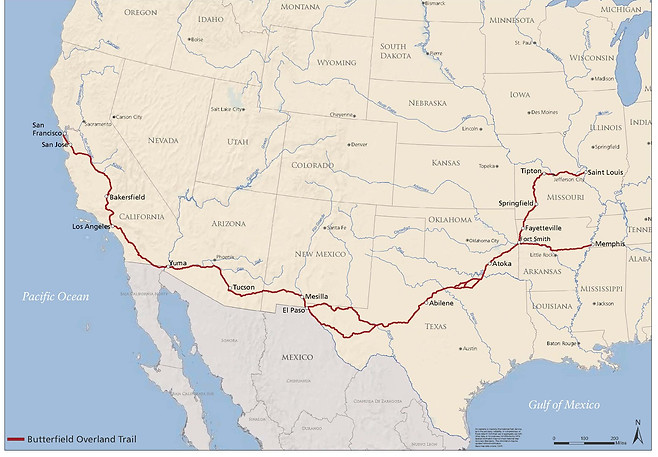
The Butterfield Overland Trail has a rich history in America. The routes were originally pioneered by John Butterfield and the Butterfield Overland Stage Company as they traveled across the country from the eastern cities of Saint Louis, Missouri and Memphis, Tennessee all the way to San Francisco, California in the mid-1800's. In Riverside County, the trail passes through Temecula, Murrieta, Lake Elsinore, Temescal Valley and Corona. It is also known as the "oxbow" route since it takes a u-shaped curved path giving stagecoach travelers a way avoid the dangerous Rocky Mountains and their harsh winter snows.

In 2009, legislation was enacted to develop a special resource study to evaluate options to protect and interpret the route. This includes work towards achieving a national historic trail designation and officially adding the route to the National Trails System. The study project also involves developing collaborations among the National Parks Service, Federal, State, and local government agencies as well as private & non-profit entities. The trail and historic sites along the way are owned by both public and private entities and participation in the national historic trails program is voluntary.
The Butterfield Overland Trail Project represents a joint effort between the City of Lake Elsinore, the City of Corona, Riverside County Regional Park and Open Space District, Riverside County Board of Supervisors, Riverside County Habitat Conservation Agency, and Riverside County Park District Advisory Commission. Technical assistance on this project was provided by the National Park Service’s Rivers, Trails, and Conservation Assistance (RTCA) program.
Read more about our project: Butterfield Overland Trail Project


Hidden Valley Restoration Project
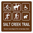
Salt Creek Trail Projects
El sendero del proyecto Salt Creek Trail consistirá en un sendero para bicicletas Clase I de superficie dura y un sendero peatonal de superficie blanda. El sendero estará ubicado a lo largo del lado norte del canal de control de inundaciones de Salt Creek entre Goetz Road y Antelope Road en Menifee y a lo largo de la avenida norte de Domenigoni Parkway entre Sanderson Avenue y Searl Parkway en Hemet.
en Menifee y Hemet

¿Qué tenemos cocinando estos días? ¡Algunos proyectos increíbles!
El sendero del proyecto Salt Creek Trail consistirá en un sendero para bicicletas Clase I de superficie dura y un sendero peatonal de superficie blanda. El sendero estará ubicado a lo largo del lado norte del canal de control de inundaciones de Salt Creek entre Goetz Road y Antelope Road en Menifee y a lo largo de la avenida norte de Domenigoni Parkway entre Sanderson Avenue y Searl Parkway en Hemet.
El sendero del proyecto Salt Creek Trail consistirá en un sendero para bicicletas Clase I de superficie dura y un sendero peatonal de superficie blanda. El sendero estará ubicado a lo largo del lado norte del canal de control de inundaciones de Salt Creek entre Goetz Road y Antelope Road en Menifee y a lo largo de la avenida norte de Domenigoni Parkway entre Sanderson Avenue y Searl Parkway en Hemet.
¿Qué tenemos cocinando estos días? ¡Algunos proyectos increíbles!


Historia aportada por el Departamento de Transporte del Condado de Riverside.
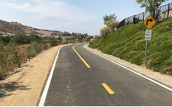
A partir de la década de 1960, los desarrolladores construyeron un amplio canal de tierra para el control de inundaciones a lo largo de Salt Creek para llevar agua de tormenta a 16 millas desde la ciudad de Hemet hacia el oeste a través de la comunidad de Winchester y a través de la ciudad de Menifee, donde el agua eventualmente fluiría hacia el lago Elsinore. . El Distrito de Control de Inundaciones del Condado de Riverside (Control de Inundaciones) concibió la instalación como un equilibrio de elementos de “Función, Medio Ambiente y Recreación”. Como tal, el condado planeó un sendero recreativo regional a lo largo de todo el canal y, en la década de 1990, el sendero Salt Creek se convirtió en uno de los cinco senderos esenciales identificados en el elemento de circulación del Plan General del Condado.
El Salt Creek Trail de 16 millas será un sendero esencial de este a oeste para el sistema de senderos del oeste del condado de Riverside con accesibilidad a hogares, escuelas, negocios y enlaces planificados con senderos más pequeños. Los senderos regionales cumplen con los objetivos de aumentar los modos de transporte activos y disminuir las muertes de ciclistas y peatones, al tiempo que brindan una alternativa a los viajes en vehículos que funcionan con gasolina, que es clave
para lograr los objetivos de calidad del aire estatales y locales.
El Parque Regional del Condado de Riverside y el Distrito de Espacios Abiertos (Park District), que supervisa los senderos regionales en todo el condado de Riverside, solicitó y recibió una subvención de $ 5 millones del programa federal de Mitigación de Congestión y Mejora de la Calidad del Aire para construir las primeras 5 millas de Salt Creek Trail.
En una asociación del condado de tres departamentos, Flood Control proporcionó la propiedad que consta de un camino de mantenimiento de tierra a lo largo del lado norte del canal, el Departamento de Transporte administra el programa de financiación, el diseño y la construcción del proyecto y el Distrito de Parques finalmente operará y mantendrá el sendero regional.
Esta primera fase de construcción incluye un segmento de 4 millas en la ciudad de Menifee y un segmento de 1 milla en la ciudad de Hemet. El sendero generalmente consiste en un carril para bicicletas pavimentado de 12 pies de ancho con un camino de superficie blanda adyacente, donde el espacio lo permite. Las señales de tráfico activadas por peatones detendrán el tráfico para que los usuarios de los senderos puedan cruzar con seguridad las calles principales. En un lugar, el sendero pasa por debajo del puente de la Interestatal 15.
Los miembros del público pueden andar en bicicleta, caminar, correr y montar a caballo por el sendero, y pueden estar acompañados de mascotas con correa. El sendero también está diseñado para ser accesible para personas con discapacidad. Los vehículos motorizados, como carritos de golf y motocicletas, no están permitidos en el sendero.
El Splash Pad
en el Parque Regional Rancho Jurupa


En 2010, RivCoParks completó un proyecto de mejora en el hermoso Parque Regional Rancho Jurupa que incluyó la adición de senderos para caminar, golf en miniatura, plataforma de chapoteo, área de juegos de rocas naturales y mejores instalaciones de estacionamiento.
Una vez finalizada, la plataforma de salpicaduras se convirtió rápidamente en un destino popular para el uso diurno dentro del parque. Con el tiempo, el área de la superficie de la plataforma de salpicaduras se deterioró y las comodidades circundantes debían cumplir con la ADA para alojar a los visitantes de manera segura.
En 2019, se aprobaron mejoras en la plataforma de salpicaduras y el área circundante para incluir la actualización de la superficie en toda la instalación, la expansión de los desagües de recuperación de agua para una mayor eficiencia del agua, mejores servicios, mejoras en el cumplimiento de la ADA, nuevas estructuras de sombra, jardinería y trabajos de reparación de riego.
RivCoParks se enorgullece de compartir con usted estas mejoras en la plataforma de salpicaduras y las áreas de uso diurno circundantes que brindarán a los visitantes y a la comunidad un lugar más funcional, compatible con la ADA y seguro para disfrutar durante muchos años.